Apart from the island tourist zone, the Mexican residential section of Cancun, the downtown part of which is known as “El Centro,” follows a master plan that consists of giant trapezoids with a central, open, non-residential area cut in by u-shaped residential streets.
Read also: The best beaches in Cancun and Riviera Maya
These open centers usually have walkways and ‘sidewalks’ around a central garden park, football fields, a library, etc. which make the mainland “Mexican” Cancún bicycle-friendly.
- The residential roads of central or ‘Mainland’ Cancún, U-shaped and cul-de-sacs, insulate housing from the noise and congestion of the main flow of traffic.
- Mainland Cancún has a central market that resembles an outlet mall, and colorful buildings on a pedestrian city block.
- Ave. Tulum is the main north-south artery, connecting downtown to the airport, which is some 30 km south of downtown.
- Ave. Tulum is bisected by Ave. Cobá.
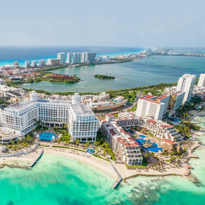
- East of Ave. Tulum, Cobá becomes Ave. Kukulcan serves as the primary road through the 7-shaped hotel zone.
- Ave. Tulum ends on the north side at Ave. Paseo José López Portillo which connects to the main highway west to Chichén Itzá and Mérida.
- Another major north-south road is Ave. Bonampak which runs roughly parallel to Ave. Tulum.
The main ferry to Isla Mujeres is located in Puerto Juarez, on Ave. Paseo José López Portillo.
To save on the cost of installing sewer systems and other public services, the design of much of the rest of the city reverted to the grid plan after Hurricane Gilbert in 1988.
The newest upper-middle-class residential areas reflect the original plan but are much less intimate. Less expensive developments are composed almost entirely of identical one- or two-story small row houses, sometimes built around interior plazas or 4 story apartment blocks.
Until recently, most mainland buildings were four stories or shorter; since 2005, there has been an influx of condominium and luxury retail and office space concentrated along Ave. Bonampak.
Cancún’s Mainland or Downtown area has diverged from the original plan; development is scattered around the city.
The remaining undeveloped beach and lagoon front areas outside the hotel zone are now under varying stages of development, in Punta Sam and Puerto Juarez to the north, continuing along Bonampak and south toward the airport along Boulevard Donaldo Colosio.
One development abutting the hotel zone is Puerto Cancún, also Malecon Cancún is another large development.
Cancun Airport’s old Control Tower Memorial
Despite being a young city, Cancun has a memorial monument of its foundation on a replica of the old Airport Control Tower. The original Control Tower was a provisional wooden structure to satisfy the operative needs of the recently created airport.
Some documents of the city mention that at that time there were no other formal buildings constructed in the city, possibly the first built structure of Cancun’s recent history. The old airport was located in the same part of the city that today corresponds to Kabah Avenue.
The tower is 15 meters tall, has a staircase of 45 steps, and has a base dimension of 5 x 5 meters. The memorial was first built in 2002, with the donations of Aerocaribe, a local airline, but the structure was damaged after Hurricane Wilma in 2005.
After the claims of the local people asking to rebuild the tower memorial, a new version was built in 2010, which was later abandoned without proper maintenance until Woox Pinturas, another local wood maintenance company, donated to restore the structure to its original appearance.
Cancun’s nearby Archaeological sites
There are some small Mayan vestiges of the pre-Columbian Maya civilization in Cancún.
- El Rey (Las Ruinas del Rey) is located in the Hotel Zone.
- El Meco, a more substantial site, is found on the mainland just outside the city limits on the road north to Punta Sam.
Close by in the Riviera Maya and the Grand Costa Maya, there are more archaeological sites such as Cobá and Muyil, Polé (now Xcaret), and Kohunlich, Kinichná, Dzibanché, Oxtankah, Tulum, and Chacchoben, in the south of the state.
Chichén Itzá is in the neighboring state of Yucatán.
Source: MexicanRoutes.com – Mexico travel & vacation guide